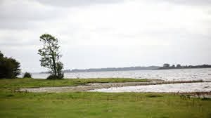
Saints Island

Saints Island is located on the southeastern shore of Lough Ree, south of the village of Newtowncashel. A narrow causeway, in existence since the 1650s, connects the island to the mainland.
The island (200 acres) is a rich habitat and breeding ground for a diverse range of wildlife and migrating birds in particular. The ruins of the Augustinian Priory of All Saints is located on the northwest corner of the island.
Contrary to long-standing local belief, it is not the site of an early Christian monastery of St. Ciaran. An Anglo-Norman lord, Sir Henry Dillon, was granted lands in south Longford, including the island in 1185, and an entry relating to 1272 in the Annals of Connacht attributes the construction of the priory to him.
Two manuscripts recounting the lives of Irish saints, which are now in the Bodleian Library in Oxford, are believed to have been written by Canon Augustin Magraidhin prior to his death in 1405. The surviving fragment of the Annals of the priory of All Saints covers only the years 1397 to 1407, but it is important for its coverage of events in the midlands at the time and includes unique discussion of King Richard II’s expedition to Ireland.
Like other monasteries in Britain and Ireland, the priory suffered under the dissolution of the monasteries after 1541, first by King Henry VIII and later Elizabeth I.
The effect was such that an account by Nicholas Dowdall in 1682, just over 100 years later, already described the Saints Island house as being ruined. There was another priory of the Austin Friars at Abbeyderg.
English Poet Laureate Ted Hughes was inspired to write ‘Saint’s Island’ (1986) following a fishing expedition to Lough Ree with his painter friend Barrie Cooke.
The priory chapel is the largest surviving section of the monastery to this day. It features large gothic windows with carved stone tracery, typical of this style of architecture. The most impressive is the altar window, with its intersecting-design tracery.
The outline of the square cloister garth is visible to the north of the church, and was once surrounded by rooms such as the chapter house and refectory (dining room). These cloister buildings would have been up to two stories in height, with the monks’ dormitories and storage areas on the first floor. One latrine survives to the west of the chapel.
The abbey church and burial ground are open to the public. Please note that the church is in ruinous condition and the walls and arches should not be climbed upon.
We are here ↓


